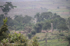
Fig.4: The Mbanza Nsundi village seen from the
Kindoki hilltop.
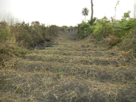
Fig.5: Kindoki. Main transect, deforestation
before setting up the test trenches.
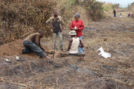
Fig.6: Kindoki. Main transect, looking East,
based on a 50-meters grid excavating 1 square
meter trenches.
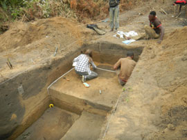
Fig.7: Kindoki. Excavation in progress in trench
5, expanding the 1 square meter trench to
study 4 pits.
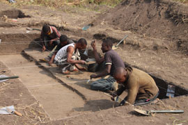
Fig.8: Kindoki. Trench 23, expanding the 1
meter trench to study the Late Iron Age village
layers.
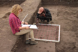
Fig.9: Kindoki. Trench 23, recording the
artefacts.
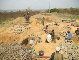
Fig.10: Kindoki. Excavation in progress of
tombs 7 and 12. Dry seaving in progress.
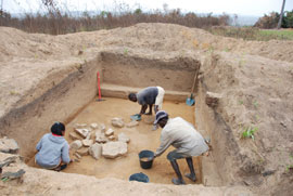
Fig.11: Kindoki. Excavation in progress of the
old stone structure in trench D to the south of
the cemetery.
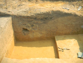
Fig.12: Lemfu. Excavation in progress in
trench 3.
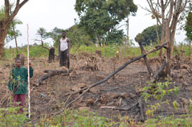
Fig.13: Ngongo-Mbata Church site. View of the
church entrance and staircase in 2012.
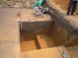
Fig.14: Ngongo-Mbata Church site. Excavation
of pit 1 in trench 1.
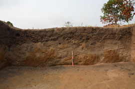
Fig.15: Ngongo-Mbata Church site. Trench 61
with a thick layer of iron slag.
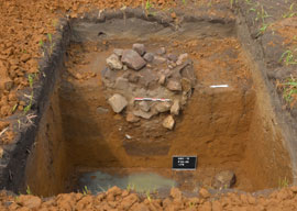
Fig.16: Ngongo-Mbata Church site. Stone
structure in trench 65.
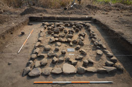
Fig.17: Ngongo-Mbata Church site. Excavation
of a house to the South of the church in
trench 1.
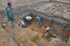
Fig.18: Ngongo-Mbata Church site. Excavation
of pit 1 in trench 1, nearing the end of its
excavation.
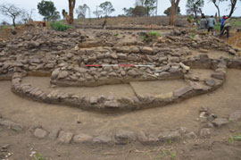
Fig.19: Ngongo-Mbata Church site. General
view of the excavated church from the West
showing the staircase and entrance.
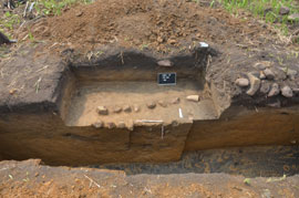
Fig.20: Ngongo-Mbata Church site. Trench 60
with stone alignments marking a grave where
three crucifixes were found.
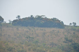
Fig.21: Ngongo-Mbata village site. The sacred
grove on top of the hill.
Archaeological fieldwork in the Lower Congo province (DRC): summer 2013
Objectives:
The KongoKing archaeological research focuses on the kingdom's former centers of political power or mbanza sites and their immediate surroundings. During the summer of 2012, a first archaeological survey was carried out in the area associated with the former kingdom's provincial capital sites of Mbanza Nsundi and Mbanza Mbata in the Lower Congo Province of the DRC (Clist et al. 2013). Following this preliminary fieldwork, it was decided to excavate the Kindoki and Ngongo Mbata Church hilltops on a larger scale during the dry season of 2013 (July to September). From our two successive base camps the survey was expanded to other sites in the vicinity. To broaden our perspective another archaeological survey was undertaken along the Inkisi River, mainly on its East bank. In addition, surveys were carried out on historical oral traditions and modern-day pottery making.
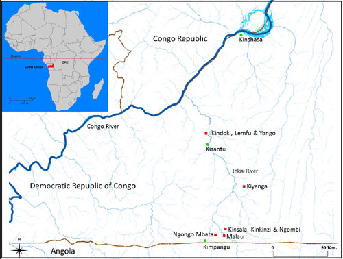
Fig. 1: Map of the Lower Congo with the approximate location of the major excavated
sites and settlements discussed in this article.
Fieldwork in the Mbanza Nsundi area
The Kindoki hilltop (05°04'069 S; 15°01'403 E) overlooking the current Mbanza Nsundi village lies in the area of the former provincial capital of the Nsundi province. On the basis of the 2012 preliminary test excavations, a total of 188 m2 were excavated in order to provide as much evidence as possible of former occupation, to date as far back as possible and to excavate all remaining tombs of the cemetery discovered in 2012 (Clist et al. 2013).
Excavations were conducted along a 700 m East-West axis and a 450 m North-South axis. Trenches were dug following a 50-meter grid resulting in a total of sixty-two 1m2 trenches with an initial depth of 1m (Fig.2).
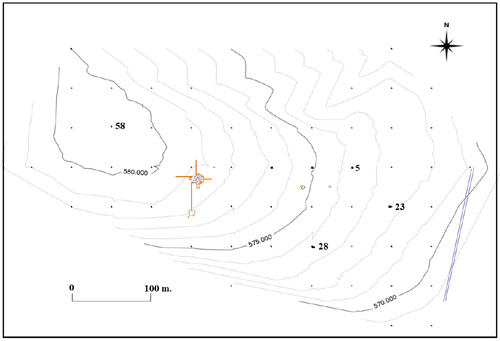
Fig. 2: Kindoki hill, position of trenches on a 50-meter grid, cemetery, extensions of
the 2012 excavations (orange area). Numbers refer to extended trenches incorporating
at least one refuse pit.
When significant concentrations of artefacts or pits were uncovered, the 1m2 trenches were expanded. This was the case with four trenches: trench 5 which yielded three refuse pits, trench 23 with two refuse pits and a concentration of pottery leading to a 34 m2 stripping of the Late Iron Age occupation layer and the further discovery of four pits, trench 28 including one refuse pit and one grave, and trench 58 with one refuse pit containing another type of pottery.
The cemetery discovered in 2012 was excavated more systematically with several trenches opened in order to find more traces of the Late Iron Age assemblage, to check whether there were no other tombs in the immediate vicinity and to further uncover a structure resembling a wall that was identified in 2012 (Clist et al. 2013). No additional graves were found in the area but a new stone structure older than the cemetery was found to its South, buried at -115 cm. However, what previously looked like a wall could not be clearly identified.
A total of eleven tombs were discovered in the Kindoki cemetery area, of which two were already excavated in 2012 (Clist et al. 2013). The nine remaining adult graves contained some grave goods. Five of these nine tombs were probably of male adults as they contained an iron saber imitating a European model. In one of these male tombs, two small copper crucifixes, one of which attached to a long fine copper chain, were also found. Two of the graves excavated in 2013 probably contained female remains, judging from the grave goods. They lacked sabers, but one of them yielded one iron ankle ring on the right leg, one iron necklace, 14 large blue glass beads, 660 shell beads from several necklaces (Pusula depauperata shells), 1140 multi-colored glass beads (on several necklaces), one Timpanotonus fuscatus shell, 1 green glass bead, 32 metal beads attached on fabric fragments, one metal chain and several pieces of fabric, possibly remnants of a shroud. The two remaining graves excavated in 2013 did not contain gender-specific grave goods.
As the location of Mbanza Nsundi may have changed over time, other hilltops in a 5 km radius around the Kindoki hilltop were surveyed and tested.
In Lemfu, a hill at the north-western end of Kindoki, 8 test pits were opened (05°03'711 S and 15°00' 527 E for trench 1), yielding a major recent occupation layer with the remains of a ceramic firing area, and a few pits. Stone Age artefacts were found in some test pits from a depth of -100 cm onwards.
In Yongo, a village some 4 km to the North of Kindoki on the road to Zongo, 2 test pits were dug to 1m (05°02' 991 S and 15°00' 103 E for test pit 1 and 05°02' 859 S and 15°00' 207 S for test pit 2). They yielded only a couple of potsherds.
Fieldwork in the Ngongo Mbata area
During August and the beginning of September, archaeological research focused on the Ngongo Mbata Church hilltop site where vestiges of a stone church probably dating back to the 18th century were first excavated by G. Schellings in August and September 1938, then later that year by M. Bequaert (Bequaert 1940; Tourneur 1939), and then again by G. Schellings in September and October 1942 (Vandenhoute 1973: 12-14). The main objective of these excavations was to find the tomb of the Flemish Capuchin missionary Joris van Gheel, killed in December 1652 and supposedly buried in the Ngongo Mbata village parish church (Hildebrand 1940: 333-334). It was thus never archaeologically studied in direct relation to the history of the Kongo Kingdom.
We were able to locate the stone church again in 2012 (Clist et al. 2013). In order to systematically excavate this site situated on top of a large sandy plateau, our team had to reopen a track of 11 km which had been disused for more than 15 years and to repair an uphill track of 2 km which had become even impassable for four wheel-drives.
Ngongo Mbata Church (05°47'081 S and 15°07'026 E). The 2013 excavations here focused on what remained of the church and the small house on its south side discovered last year in order to understand how it was built and to check whether other buildings surrounded it. Furthermore, we surveyed human settlement densities on the hilltop by sampling the area with a grid of 1m2 trenches.
Out of 58 trenches dug on the 50-meter grid over Ngongo Mbata hill on a 600 m East-West axis and a 400 m North-South axis, 13 yielded artefact concentrations worthy of expanding the study surface (Fig.3). Several refuse pits containing indigenous pottery, stone and terracotta smoking pipes, fragments of European glass and pottery, iron tools, iron slag, and glass beads were found and will be dated.
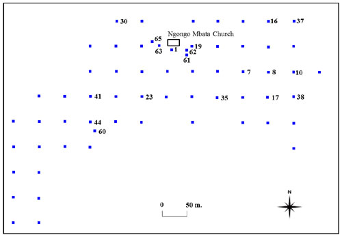
Figure 3: Ngongo Mbata hill: position of trenches on a 50-meter grid and position
of the church. Numbers refer to extended trenches incorporating at least one refuse pit.
Systematic auger testing around the church was carried out to check whether other stone buildings similar to the house discovered in 2012 or other structures could be uncovered. This led to the opening of several trenches, 71 m2 in total.
In trench 61, thousands of iron slag pieces, a few tuyeres fragments and sherds were found, clearly a refuse zone of an important iron production area nearby.
In trench 62, auger testing led to the discovery of a refuse pit containing an interesting collection of potsherds and tobacco pipes.
In trench 63, three stone walls, presumably built during two separate periods, were uncovered and a concentration of iron slag was discovered.
In trench 64, a small part of another wall was found.
In trench 65, a round stone structure was found immediately below the humic layer. Situated 26 meters west of the church staircase, this isolated structure could be the stone base of a large standing wooden cross. It resembles the stone base of similar wooden crosses depicted on several watercolors of Capuchin missions in the manuscript of Bernardino Ignazio da Vezza d'Asti from the mid-18th century.
The 2012 excavations revealed the remains of a small stone building of 3.80 x 2.80 m situated 8 m south of the church and having a long axis running parallel with the church's outer wall. This year, the 2012 trench was extended to 20 m2. A first extension enabled us to draw the complete plan of the building and to situate its entrance on the east side. A further deepening of the trench resulted in the excavation of a surface of 4 x 5 m in total with filling layers extending to -3 m. This was still not sufficient to reach the southern and eastern limits of the pit extending further under the building. This huge pit most likely results from the massive removal of earth needed for the construction of the church platform. The refill contained hundreds of potsherds, fragments of stone and terracotta smoking pipes, iron slag and charcoal. At the bottom, a broken bronze bell was discovered. It probably belongs to an older church in perishable material, as we know that a church existed in the village in 1648 when two Capuchin missionaries arrived there (Hildebrand 1940: 232).
The remains of the stone church, already excavated in 1938, were uncovered over a surface of 300 m2. Its length was 18.73 meters from East to West, and its width was 9.11 meters to the West, and 11.38 meters to the East according to what is left of the walls. A stone and padded earth staircase provided access to the West side of the building. Several tombs were dug into its floor. All tombs inside the building had already been emptied during the 1938 excavation. We registered the position of some of them in order to gain a better understanding of the context of the artefacts curated since 1938 at the Royal Museum for Central Africa in Tervuren (Belgium). Moreover, a 1m large and 20 m long stratigraphic trench was opened through the church along a North-South axis to check some of the observations made by Bequaert (1940) and Vandenhoute (1973). The stratigraphy clearly shows the underlying yellowish clay on which a talus was set up with earth excavated nearby. Several tombs were subsequently dug into the talus. The presence of a posthole dug from the layer running under the north wall's foundation suggests an older construction phase.
In addition to the trenches regularly dug along the 50-meter grid, trench 60 was opened due to a concentration of large stones, topping what turned out to be a small graveyard. Four tombs were identified and one of them was fully excavated. They were oriented the same way as the ones in the church cemetery. Although the human remains are limited to a few teeth and bone fragments, a group of three small copper crucifixes were found in the only grave that was fully excavated. They are similar to a crucifix which Volper (2011: 34, fig.7) approximately dates between the 16th and 18th century.
In several trenches on the hilltop a quartz industry was found usually around - 80 cm. In trenches 41 and 44, the initial excavation was extended to 4 m2 to study the lithic concentrations.
Ngongo Mbata Village (05°46'429 S and 15°06'902 E). In addition to the 2012 test excavations, seven new 1m2 test pits were dug in order to acquire a better insight in the Iron Age sequence. The first five test pits were positioned on the southern slope of the hill. All of them yielded some artefacts from the surface to -40 cm and some quartz artefacts were encountered after -60 cm. Two additional test pits were sunk on the hill ridge to the west of the 2012 test pits. Iron Age artefacts were collected again down to -40 cm. The area suitable for a settlement on top of Ngongo Mbata village hill is limited. This may explain why, based on a preliminary analysis of the pottery and the modern 14C date obtained (see Clist et al. 2013), only the remains of a recent occupation were found and nothing earlier, except for the LSA layer.
Malau (05°47'00 S and 15°09'39 E). Test pits were sunk around Malau village and on the east bank of the Inkisi River. They only revealed potsherds from the surface down to -20 or 40 cm. On the east bank, a 1m2 test pit was dug on a hilltop overlooking the river; some potsherds were recovered between the surface and -60 cm, while a dense concentration of lithic was found between -60 cm and -100 cm. The latter consists of a mostly quartz assemblage. Downslope, a final 1m2 test pit was opened on a flat surface closer to the river. From the surface to -60 cm several potsherds were found there.
Prospections alongside the Inkisi River
Two weeks of prospections were carried out to survey the zone linking Mbanza Nsundi and Ngongo Mbata, the two major sites mentioned previously. The Inkisi river valley had never been subject to any archaeological research, although it is known to have hosted important centers of human life and activity during the Kongo kingdom period, such as the capitals of the three major eastern provinces: Mbata, Mpangu and Nsundi (Hilton 1985: 7; Thornton 1977: 523, 1983: 4). The Jesuit Priest André Cordeiro described the eastern region in 1622 as 'the largest, the richest, and the most abundant in all things' (Jadin 1968: 365, translated by Thornton 1977: 523). Following the main roads, the area between Kisantu and Ngidinga was surveyed and later on those between Kisantu and Luila, Kisantu and Zongo and Mbanza-Ngungu and Gombe Matadi.
In addition to scrutinizing roadside verges, interviews with villagers were helpful in locating archaeological material and abandoned villages. If possible, the places mentioned were physically surveyed and described (type and density of the material found and GPS-positioning of find spots). Surface samples of the different materials were collected as a reference. Over 200 GPS-locations were thus recorded referring to find spots of pottery and pipe fragments as well as traces of ferrous metallurgical activity in the form of accumulations of slag and remains of furnaces. The area south of Kisantu yielded notably more archaeological remains than the surveyed areas to the north.
In addition to the survey, test excavations were carried out on four hilltops. For comparability, test pits were always 1m² large, excavated up to 1m deep and positioned in a check pattern 10 m apart from each other.
At Voka di Mbanza (situated in the village of Kiyenga: 5° 31.482 S and 15°17.147 E) (fig. 1), 5 test pits were opened. In three of them, refuse pits containing mainly potsherds and pipe fragments were found. Three other hilltops surrounding Mbata Kulunsi were tested as well. Mbata Kulunsi or Mbata Makela would have been the capital of the Mbata province before its devastation by the Yaka in 1649 (Van Moorsel 1964: 293), while its name makela (slag) indicates the presence of metallurgical activity. 17 test pits were opened at Kinsala (05°43.921 S and 15°08.505 E), 8 at Kinkinzi (05°43.778 S and 15°08.567 E) and 9 at Ngombi (05°43.586 S and 15°08.488 E) (fig. 1). While the latter turned out to be rather poor with only a dozen artefacts in each test pit, Kinsala and Kinkinzi contained larger quantities of pottery and slag. In the lowest level (-80/-100 cm), a lithic industry on quartz and jasper was encountered.
On some occasions (e.g. in Mbanza Mpangu (05°01.872 S and 15°07.237 E), Bala Mayabi (05°09.363 S and 14°50.374 E) and Nsangi Nsona (04°52.629 S and 15°04.703 E), detailed interviews were conducted on historical and ethnographic issues, such as clan and lineage systems, male and female title holders (mfumu and ndona), regalia, funerary customs and voka, the abandoned villages which continue to structure space for current-day Kongo people.
Ethnographic survey
Throughout the fieldwork season, an ethnographic pottery survey was carried out. Besides trying to reconstruct production and distribution areas, it aimed at describing and recording chaînes opératoires through interviews and observations of (former) potters. Four (retired) artisans were interviewed and it was still possible to observe three potters in the villages of Songololo (05°04'144 S, 15°00'958 E) and Nsangi Binsu (05°38'590 S, 15°12'619 E); the latter village had been identified and studied by the KongoKing linguists in 2012. Even though most people stopped buying or using ceramics at least a decade ago, three production centers could clearly be identified. Since the KongoKing project unites linguists and archaeologists, special attention was given to pottery-related vocabulary.
Palaeo-environmental setting
As was done at Kindoki hill in 2012 (Clist et al. 2013), a 3 m deep column of soil was collected at Ngongo Mbata for further sedimentological, palynological, phytolithic, and geochemical analysis.
Conclusions
The 2013 excavations at the Kindoki and Ngongo Mbata hilltops amount to a surface of 788 m2 in total, in addition to the 319 m2 excavated in 2012. The extensive sampling on entire hilltops further complemented by systematic excavation led to the uncovering of a wealth of archaeological objects from the Late Iron Age, such as ceramics, pipes, beads, shells, iron slag, Christian and status-related grave goods. These provide new data on material culture, settlement patterns, burial customs, trade networks and early Christianity within the realm of the Kongo kingdom. The spatial distribution of artefacts and structures, such as tombs, refuse pits and stone buildings, on both sites provides new insights on the internal layout of Kongo settlements and may shed some light on their historical, political and commercial significance.
Limited excavations and surveys in the vicinity of these two sites indicate that the hilltops were not permanently settled throughout the Late Iron Age. Moreover, no Early Iron Age material has been identified so far.
In addition, ethno-archaeological studies of ceramic production during the last century were carried out along a 100 km axis. This will lead to a better understanding of archaeological ceramics and the local cultural sequence.
Based on those results and the ongoing analysis of the material collected, more fieldwork will be carried out by the KongoKing team during the summer of 2014.
Acknowledgements
Our thanks go first to the groupement and village chiefs of Mbanza Nsundi, Kindoki, Lemfu, Sabala, Malau, Ngongo Mbata, and Kimfuti and to the more than 80 villagers of Mbanza Nsundi, Kindoki, Lemfu, Songololo, Mbanza Mbata, and Ngongo Mbata who excavated with us.
In Kinshasa, administrative chores were made easier thanks to the staff of the Institut des Musées Nationaux du Congo (IMNC), especially J. Imbongo, C. Mambu, and J. Yogolelo.
In the field, the KongoKing team (B. Clist, P. de Maret, A. Livingstone-Smith, and PhD students E. Cranshof, M.Kaumba, I. Matonda) was helped in July by J. Yogolelo (IMNC), N. Vanhaeren (Geography Department, Ghent University), C. Verhaeghe and A. Sengelov (Archaeology Department, Ghent University), and in August by C. Mambu, J. Yogolelo (IMNC), and E. Vergaert (Archaeology Department, Ghent University).
In Kinshasa, the Procure Sainte Anne, apart from being our Kinshasa base, enabled us to store our field equipment and vehicle; without their help our tasks would have been even more challenging.
We thank Dr. D. Fehse of the Zoological State Collection in Münich, Germany, for the preliminary identification of the Pusula depauperata shells.
Last but not least, our warmest thanks go to M. Goethals, secretary of the Department of Languages and Cultures, Ghent University, who devoted much of her time to help with logistics and accounting.
References
Bequaert, M. 1940 Fouilles d'un cimetière du XVIIe siècle au Congo Belge. L'Antiquité Classique 9: 127-128.
Bernardino Ignazio da Vezza d' Asti c. 1750, Missione in prattica. Padri cappuccini ne Regni di Congo, Angola et adiacenti, Unpublished manuscript, Torino Municipal Library, MS. 457.
Clist, B., de Maret, P., de Schryver, G.-M., Kaumba, M., Matonda, I., Cranshof, E., and Bostoen, K. 2013. The KongoKing Project: 2012 fieldwork report from the Lower Congo Province (DRC). Nyame Akuma 79: 60-73.
Hildebrand, P. 1940 Le Martyr Georges de Geel et les Débuts de la Mission du Congo (1646-1652). Antwerp: Archives des Capucins.
Hilton, A. 1985. The Kingdom of Kongo. Clarendon Press; Oxford University Press, Oxford; New York.
Jadin, L. 1968. Relations sur le Congo et l'Angola tirées des archives de la Compagnie de Jésus 1621-1631. Academia Belgica, Bruxelles & Rome.
Thornton J.K. 1977. Demography and History in Kingdom of Kongo, 1550-1750. Journal of African History 18 (4): 507-530.
Thornton J.K. 1983. The Kingdom of Kongo : civil war and transition, 1641-1718. University of Wisconsin Press, Madison.
Tourneur, V. 1939 Médailles religieuses du XVIIIe siècle trouvées au Congo. Revue Belge de Numismatique et de Sigillographie 91: 21-26 .
Vandenhoute, J. 1973. De begraafplaats van Ngongo Mbata (Neder Zaïre). Unpublished MA thesis, Rijksuniversiteit Gent.
Van Moorsel, H. 1964. Recherches sur le P. Georges de Geel mort à Ngongo-Mbata en 1652. Ngonge: Carnets de Sciences Humaines 16: 293-294.
Volper, J. 2011. Ora pro nobis. Etude sur les crucifix bakongo. Paul Louis, Bruxelles.
